
There is a bear in Miller Yard.
A small teddy bear
Strapped tightly to a brake stick pole.
Little bear is grimy and balding in spots.
But it keeps watch.
There is a bear in Miller Yard.
A small teddy bear
Strapped tightly to a brake stick pole.
Little bear is grimy and balding in spots.
But it keeps watch.


Norfolk Southern belt buckle unearthed at a local antique store by my buddy. It’s 3.75″ long and 2.5″ wide. Made by Hoover’s Mfg. Co. of Peru IL. The buckle has been treated fairly badly; scratched up.


This is the yard looking NNE from the Mary Street bridge (36.6001, -82.1760) in Bristol VA. That’s an active locomotive on the left.

This is looking SSW.

I’ve gone by this many times. I always thought “I’ll get a picture of that next time I go by.”
So, I did. A passenger car (the Bristol) and a Southern caboose on the Wes Davis Greenway in Bristol TN.

Some of the ice we ran into hiking up the Doe River Gorge in 2011. It was also raining…and cold.


This is Norfolk Southern’s Yuma yard looking east (top photo) with the Smith signal unit to the left. Bottom photo is looking west. This yard, 3 miles west of Frisco yard, is mostly used for storage now. It is .86 mile long with seven tracks. Thanks to the CSX Transportation Historical Society website for information on this yard.


This gives an idea of how massively these railroad companies built when they needed to. I took this under a double track trestle over the Bluestone River- and an out-of-service single rail line- in West Virginia at 37.32335N,81.32700W. Just behind me is Pocahontas Avenue north of Pocahontas VA. The trestle above is about 665’ in length.

I’ve posted this before. It’s an out-of-service trestle between Appalachia VA and Big Stone Gap and is part of a pleasant walking trail. You can access the trail in Appalachia, just off the highway and walk along the old L&N tracks past Bee Rock Tunnel and on along the trail. Bee Rock Tunnel is the third shortest tunnel in the United States. Second is the tunnel I mentioned in Gallatin TN. Shortest is Backbone Ridge at 20′, plus or minus, in Shady Valley TN. After Bee Rock Tunnel is Callahan’s Nose Tunnel, then this trestle and on to Big Stone Gap. This should be a fine walk in fall.

This is on Hwy 606 just below Lower Exeter VA…N&S stallion locomotives coming slowly up the grade


Towers Tunnel is at 37.257, -82.327. The date on the facing is 1926, but that only notes when the tunnel was reinforced and faced with concrete. The actual tunnel is older than that by maybe 10 years or so. This tunnel is 921’in length and cuts through a ridge between two geological features in the park “The Chimney” and “The Towers”. You can’t see the end because it curves to the right.

From 1986, this 2″ pinback recognizes a campaign to keep Conrail alive, after a takeover attempt by Norfolk-Western. In 1987, Conrail was released by the government to become a private enterprise. As of the late 1990’s, both CSX and Norfolk-Southern share ownership of Conrail.

I don’t really know how to date this little key fob. It’s made of that plastic material that feels like a gummy bear would. Disclaimer: I enhanced the gold lines a bit. They’ve faded badly.
I found two post cards of the Reader Railroad recently. Here’s a link: Reader Railroad
It’s really annoying. I thought I had a handle on the dating of these cards, but, when I told a colleague about it, I realized that I had been totally wrong. The cards were printed by Koppel Kolor (or Color) Cards in Hawthorne, New Jersey. The company’s main building appears to have burned down in the mid 80s.
Update on the dating for these cards: mid-1960s. See comment below courtesy of thedigitalphilatelist


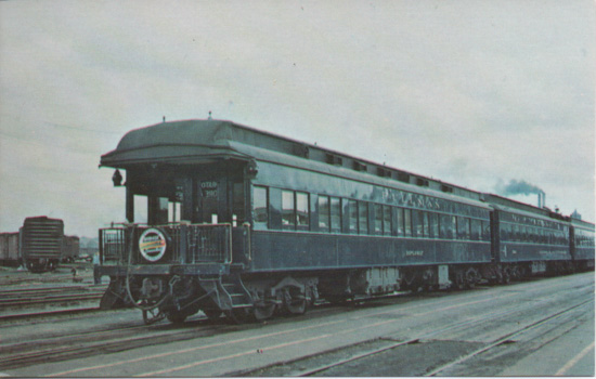
The Audio-Visual Designs Company did a lot of railroad-related postcards in the latter half of the 20th century. Railroad-line.com states that the company was famous.

As of 8/24/19, this was parked on a siding near Memorial Park in Johnson City TN.


The lower bridge was built in the late 1890s by the Virginia & Southwest Virginia rail road (V&SW). That line was absorbed into the Southern Rail Road in 1916, just a year after this card was mailed.
The upper one, the Copper Creek Viaduct (a word the Marx Brothers had fun with in The Cocoanuts) was built by the C.C. & O in 1908. The stated height now is 185′ , measuring from the river below.
You barely read the writing down the length of the viaduct, but I believe it says “crossed this just today” or something to that effect.
The post card itself appears to have been printed in Germany before WWI.


This is looking south at approx. 36.0720N, 82.3987W.
The card was printed by Curt Teich in Chicago. It’s one of the “C” series of post cards issued between 1905 and 1926. The Curt Teich records for this period are scanty and this number isn’t listed anywhere that I can find. Nicely printed, though, and hand colored at the factory before the separations were shot for the print run.


Following the track of the old ET & WNC Rail Road through Doe River Gorge is a fine hike, except in winter. If there’s been some snow or freezing rain, getting across the derelict bridges can be dangerous.
This card was published by the American News Company of New York, but it was printed in Germany before the start of WWI.
I can’t read the place name on the postmark, and I’ve tried. All I can see if the final “…ONE”.
I hope Dolly got home okay, though.
This is a Real Photo Post Card. The paper was made by Ansco of Binghamton NY. The trademark is CYKO. That trademark seems to have been discontinued in 1928, when Ansco merged with Agfa.
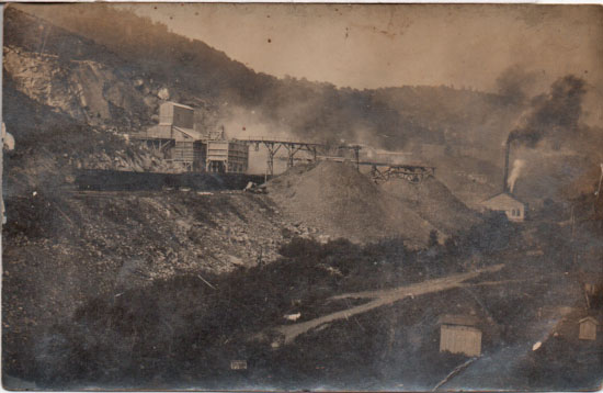
I acquired this card in East Tennessee from an individual who also didn’t know where it was, but was sold to me on the basis of the railroad stuff in the picture. I figured I could work out where it was. But I’ve had no luck. These places came and went fairly quickly in the early days of commercial coal mining.

Actual size is 4″ x 2″. It’s not an iron-on. I found this at the 2019 Antique Bottle and Collectibles sale at the Appalachian Fairgrounds. I always find something at that sale.

T. D. Moore, Jr. was General Manager from 1968 until, according to Goforth’s Building the Clinchfield, he was dismissed for fraud in 1979.
The pass is 5 x 3.25″ and is blank on the reverse.

A line of Washington County (VA) Co-op GSI hopper tanks in Abingdon.


This old ballast regulator, devoid of any nameplates or other information (except that its motor was made by Detroit Diesel), sits just east of the former Greenbrier (sic) Dock near Vansant in Buchanan County VA. The Greenbrier facility closed in 2006. I have been unsuccessful in finding out when it was constructed. In early 2000’s, Greenbrier Dock was loading coal from the Lovers Gap mine, just a few miles away.


